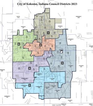
The city’s new City Council district map for the next 10 years has been set.
The Kokomo City Council on Monday voted 8-0 to approve newly drawn council districts crafted in tandem by Kroger, Gardis & Regas, an Indianapolis law firm hired by the council, and Council president Ray Collins, R-District 3, who was voted to be the council’s redistricting coordinator. Councilman Tony Stewart, R-at-large, was absent from Monday’s meeting.
The new map keeps each council member in their current district and is not radically different from the map of the last 10 years, but it does put some residents, most notably on the city’s south and west sides, into new districts.
The changes made were done in large part to fix the population unevenness of the previous council district map caused by the slew of annexation done by the city over the last 10 or so years and to make most districts more compact. All municipal legislative maps have to be redrawn by the end of the second year after each new U.S. decennial census if the districts’ populations have become unequal.
The new map’s population deviation is 4.77%, with each district having around the ideal district population of 9,934 (the city’s total population of 59,604 divided by six). That’s under the 5% goal the City Council was aiming for.
Collins thanked all who participated in the redistricting process in a speech at the beginning of Monday’s meeting.
“I did this so that we would be open and honest and have input from the public,” Collins said. “It was all new to me. … I’m very pleased with the process that we did in involving the public and giving them a chance for comment.”
The City Council’s approval comes one month after it kicked off the redistricting process.
As part of the process, the board sought input from the public in the form of public submitted district maps and public comment at both hearings in which the council voted on the redistricting ordinance.
That said, very little public discussion was had amongst City Council members regarding the two public submitted district maps — one by Andrew Ellison and another by former city councilman and Kokomo police officer Kevin Summers.
Ellison is a Kokomo High School and Indiana University Bloomington graduate with a degree in political science. According to his LinkedIn page, he’s worked in a handful of Illinois and Michigan Democratic state senate or representative campaigns and drew up redistricting maps for the city of Elkhart and the Indiana Democratic Senate Caucus.
While both Ellison and Summers were given the opportunity to present their proposed district maps — Ellison being the only one to accept that offer — the City Council did not publicly debate or discuss during their two public meetings the proposals from Ellison and Summers or from the one proposed by Kroger, Gardis & Regas, which was presented by one of the law firm’s attorneys, Doug Kowalski.
Both Councilmen Matt Grecu, R-at-large, and Tom Miklik, R-District 6, said publicly earlier this month after the board’s Nov. 14 meeting that they preferred the law firm’s proposed map because it had a lower deviation percentage than the other two.
Ellison on Monday criticized the redistricting process and the timing in when it was done, calling the public input aspect of the redistricting as simply a front and surmising that the City Council was always going to pick whatever its hired law firm and Collins came up with. Local Democratic Party leaders voiced similar criticisms earlier this month.
“There’s not been a good discussion over these maps,” Ellison said. “There’s been statements that we’ve had a process, but I don’t feel like we have. Putting this in the middle of an election season when you know people with elections and are not able to focus and participate in the process.”
Coming to the City Council’s defense was Kowalski, who noted state law does not require any public input in the redistricting process.
“We made the maps based on the smallest change possible to make sure the population is even as population,” Kowalski said. “Equal population means everybody’s vote matters. Everybody’s vote counts the same. The map presented to you by the redistricting coordinator (Collins) has the lowest population deviation. That means, of the maps presented, it is the most fair. …This council has done a good job allowing the public to participate. It’s not required by law, so we appreciate the opportunity to work with you and have this public engagement.”
(Except for the headline, this story has not been edited by PostX News and is published from a syndicated feed.)
