

RADAR CHECK AT 10:26AM
As for now, the radar is free from any shower and thunderstorm activity across Alabama, but we could see some spotty showers and storms this afternoon and into early evening. Temperatures across the area are already up in the mid to upper 80s, and those will only continue to climb into the 90s. Florence is the hot spot at 88 degrees, while the “cool” spot was Birmingham at 82 degrees.
ALABAMA HEATS UP AGAIN TODAY – ONLY A FEW STORMS AROUND
Hot, summer-like weather continues across Alabama today, with most of us staying dry. In North Alabama, a weak upper-level disturbance is slowly drifting southwest through the Tennessee Valley this morning, and there’s also a low-level feature helping to stir up the atmosphere just a bit. These two ingredients, along with leftover moisture from previous days, may fire up a few isolated showers or storms this afternoon, especially west of I-65. Even though drier air is moving in from the east, the strong summer sun will still have enough energy to build up some scattered cumulus clouds, and in some spots, that could be just enough to spark a quick downpour or thunderstorm. Still, rain will be the exception rather than the rule.
In Central Alabama, that outflow boundary that helped fire off storms on Friday has moved out of the area, now likely sitting well to the west and northwest of the state. In its place, drier air has worked in, and there’s also a zone of sinking air on the western edge of Tropical Storm Chantal offshore, which is helping to squash any thunderstorm development. This means the vast majority of Central Alabama will stay dry today, with only a slim chance of a pop-up storm in a few lucky (or unlucky) neighborhoods.
Whether you’re headed to the lake, the pool, or just spending time outside, keep in mind it’s going to be another hot one. Afternoon highs will climb into the lower and middle 90s, and with the humidity sticking around, it will feel even warmer — more like the upper 90s in some places. Make sure you’re staying hydrated, taking breaks in the shade, and wearing sunscreen if you’re outdoors for any length of time.
Looking ahead through the rest of the holiday weekend, a ridge of high pressure will stay in place across the region, which means hot and mostly dry conditions will stick around. However, we’re keeping an eye on a series of small disturbances that could begin to weaken that ridge a bit by Sunday and Monday, possibly opening the door to a few more widely scattered showers and storms.
AT THE BEACHES
From Fort Morgan to Destin, today will feature mainly sunny skies with only a slight chance of a few showers and storms. Highs will be around 90 degrees with winds becoming southeast around 10 MPH. From Sandestin to Magnolia Beach (including Panama City Beach), skies will be mostly sunny with only a slight chance of a few showers and storms. Highs will be in the lower 90s with east winds at 5 to 10 MPH.
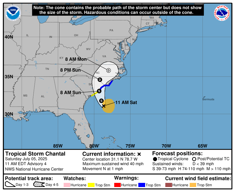
CHANTAL NEARS CAROLINAS WITH WINDS, RAIN, & COASTAL HAZARDS
At 10:00AM, Tropical Storm Chantal is located about 135 miles south-southeast of Charleston, South Carolina, moving slowly north at 1 mph with maximum sustained winds of 40 mph. A turn toward the northeast is expected by Sunday night, with landfall likely along the South Carolina coast Sunday morning. Tropical Storm Warnings now extend to Surf City, North Carolina. Heavy rain of 2 to 4 inches (locally up to 6 inches), storm surge of 1 to 3 feet, and tropical-storm-force winds are expected along the coastal Carolinas through early Monday. Isolated tornadoes and dangerous surf with life-threatening rip currents will also be concerns through the weekend.
Category: Alabama’s Weather, ALL POSTS, Social Media, Tropical
(Except for the headline, this story has not been edited by PostX News and is published from a syndicated feed.)