

RADAR CHECK: As of 10:19AM, we have mainly a clean sweep across the state of Alabama, except for a brief shower just to the west of Hazel Green, as it was moving to the southeast. That will most likely change as we get into the afternoon hours. Temperatures at this time were in the upper 70s to the mid 80s across the state. Andalusia was the warm spot at 86 degrees, while it was 77 degrees at Gadsden, which is the cool spot. Birmingham was at 82, Tuscaloosa was at 80, Huntsville was at 82, Montgomery and Mobile were both at 83.
REST OF TODAY: It will be another hot and muggy June day across North and Central Alabama, with temperatures climbing into the upper 80s and lower 90s this afternoon. Dewpoints are running high, which means it’s going to feel more like the upper 90s to near 100 in many places. While we’re not under a formal Heat Advisory today, heat safety is still important — take breaks, stay hydrated, and don’t overdo it outside. The atmosphere is very unstable and loaded with moisture, so any storm that forms could produce very heavy rain, with rainfall rates up to 1 to 2 inches per hour. Storms will move slowly, and that raises the risk of localized flooding in some spots. A few storms may also bring gusty winds and lots of lightning. We’re not expecting organized severe weather, but the Weather Prediction Center has placed much of the area under a marginal risk for excessive rainfall today due to the potential for flash flooding. Storms will begin to fade after sunset, but the heat and humidity will stick around through the night. Expect lows in the upper 60s to lower 70s with the possibility of some patchy fog late tonight.
SUNDAY’S FORECAST: We can expect another round of classic Alabama summertime weather — hot, humid, and stormy in spots. A deep layer of tropical moisture remains in place over the state, and with temperatures climbing into the upper 80s to near 90 by afternoon, we’ll have just the right ingredients for more scattered to numerous showers and thunderstorms. Most of the activity will be driven by daytime heating and leftover outflow boundaries, so expect storms to flare up in the afternoon and early evening hours. Storms will once again be slow-movers, which means heavy rain could quickly lead to ponding on roads or localized flash flooding, especially in areas that saw rain on Saturday. Gusty winds and plenty of lightning can’t be ruled out.
THE WORK WEEK AHEAD: Looking ahead to Monday and Tuesday, we’ll be shifting into a wetter pattern across Alabama as a cold front moves in from the north. This front is tied to a large upper trough sliding down from Canada through the Great Lakes and Ohio Valley — and it’s going to bring some changes. Expect scattered to widespread showers and thunderstorms both afternoons, with rain chances running higher than what we usually see during the summer. Coverage could reach 60 to 90 percent at times, especially across northern counties.
There’s plenty of moisture in place, so heavy rainfall is likely with the stronger storms, and that keeps localized flooding on the table — especially in areas that saw multiple rounds of rain over the weekend. Gusty winds and frequent lightning will also be possible with storms both days, but widespread severe weather isn’t expected at this point. Highs on Monday and Tuesday will generally stay in the low to upper 80s thanks to the clouds and rain, but it will still feel sticky with heat index values climbing into the 90s.
By mid to late week, we may finally catch a break. As the front slips south and drier air tries to nose in behind it, rain chances should begin to back off, especially by Thursday and Friday. We’ll also see temperatures start to climb again, with highs returning to the lower 90s and heat index values pushing close to 100 degrees in some spots. That said, we’ll still hang onto at least a small chance of a stray shower or storm each afternoon — this is Alabama in June, after all.
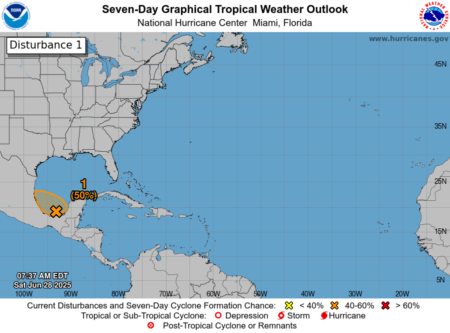
TROPICAL UPDATE: We’re keeping an eye on an area of low pressure sitting in the eastern Bay of Campeche, just off the coast of Mexico. This system — known as Invest 91L — is producing a broad area of disorganized showers and thunderstorms, stretching across parts of the Yucatán Peninsula and surrounding waters. There’s still a window of opportunity for it to organize a bit more today or tomorrow, and if it does, we could see a brief tropical depression form before it moves inland. As of now, the National Hurricane Center gives it a 50 percent chance of development over the next 48 hours and again over the next 7 days.
Regardless of whether or not it officially becomes a named system, heavy rain will be the main issue, especially for parts of Belize, Guatemala, and southeastern Mexico, where flooding is possible. An Air Force Reserve Hurricane Hunter aircraft is on standby to check it out later today, if needed. The good news for us here in Alabama — and across the rest of the Gulf and Atlantic basins — is that the rest of the tropics remain quiet for now. No other areas of concern are expected over the coming days.
Category: Alabama’s Weather, ALL POSTS, Social Media, Tropical
(Except for the headline, this story has not been edited by PostX News and is published from a syndicated feed.)