The things I do for the weather blog. I wanted to see how hot it’s been since the first day of astronomical summer in Kansas City… not an easy calculation to do because of the various dates of the first day of summer.
It’s the reason why we like to use meteorological starts to a season as opposed to astronomical starts to a season. We know that the calendar says summer started on the 20th this year in Kansas City… it doesn’t happen often but since 1950 there have been 11 times where summer started on the 20th.
All the other times it was the 21st.
I also had to make sure that the date of summer took into account our time zone… CDT as opposed to EDT. I think I figured things out regarding that, too. I couldn’t easily query the start to summer before 1950, but you’ll get the point here in a minute.
So, that was my project for the morning: Details to how hot it’s been to start summer in Kansas City in the discussion.
Forecast
Today: Sunny and hot. Windy as well with gusts 20-30 MPH at times developing. Storm chances may be isolated later this afternoon but by mid-evening the chances increase. Some storms may have gustier winds with them with some locally heavy rains especially north of the Metro. Highs in the lower 90s
Tonight: Storms and rain chances continue through early morning. Some areas can get locally 1-2″ worth of rain, while others may not get that much at all. Lows should drop into the upper 60s
Tomorrow: Turning sunny and remaining warm with highs in the upper 80s. Small chance of some later day storms re-firing depending on various boundaries left over. This is rather iffy.
Saturday and Sunday: Day to day chances, mostly in the PM hours and early evening. Not worth cancelling any plans for right now at least. Hot and muggy with highs near 90°. Lows 70-75°
Discussion
OK so about summer…
Let’s start easy… meteorological summer, starting June 1st through yesterday. We actually barely above average for June so far… only 4/10ths of a degree. So, meteorological summer isn’t exactly roasting for Kansas City.
We’re right in the middle of about 135 years of records… falling into 66th place through yesterday for the warmest start, just barely in the top half of summer warmth. Again meteorological summer starts on June 1st and runs till the last day of August.
But noooooooo (use your John Belushi voice from the old days of SNL) I wanted to do something harder.
")
Breaking down the more familiar astronomical season which varies in the start dates… although typically either the 20th or 21st for the central time zone. That isn’t easy in a sense.
So, let’s start with what we know… summer this year in Kansas City started on the 20th and through yesterday we have an average temperature of 83.3°.
There are other years of summer starting on the 20th. 1986, 88, 92, 96, 2000,, 04, 08, 12, 16, 20, and 24. (again this goes back to 1950). So, I had to break out those 6/20 to 6/25 years separately.
The winner in that special bracket is 1988… with an average start to summer temperature of 88.8° besting our start by 5+°(!). That was A BRUTAL summer! File that away.
Now for ALL the other summer start dates (essentially all 6/21s) going back to 1950… I had to cross check to see where the 6/20s would rank. The only other summer aside from 1988 that started hotter than this summer was back in 2016.
IF summer every year started on 6/21… this would be an easier comparison…

But again…different summer start dates.
So where does ALL of this lead too… I believe if I haven’t confused you or myself enough to this point…that THIS summer ranks as the 3rd warmest start to a summer (astronomical) in KC weather data going back to 1950. That is impressive.
So now you know….
Onwards, thankfully.
Rain chances.
So, we’re watching a persistent front that has been languishing across the Plains for days now… bringing heavy rains and some severe weather well north of the area. The heavy rains though made it into northern Missouri as illustrated yesterday this week, with some areas well over 8″ this week alone.
Here in the Metro though, not so much and the grass is starting to show stress from the last 6, soon to be 7 days of 90°+ days. Also fascinating that KCI has been either 92° or 93° every day in that run. It’s been hot and it’s been humid to rather muggy. Today is no exception to that really.
While a few on the north side did get some rain the other day, most in Kansas City did not… hence the need for rain with the hot conditions.
There is some cool air and rain cooled air north of the boundary.

While south of there the heat and higher dew points continue to stream into the Plains… and that includes us here in the Metro.
With this comes building instability this afternoon… as the sun heats areas south of the boundary to 90° or hotter things will get very unstable. The issue for areas south of the boundary is a trigger. Something to set things into motion.
No trigger (like yesterday) all the instability is wasted and then fades with the setting sun. With a trigger, boom…storms.
The key to this is that boundary. We need it to sag southwards later today. To get it to do that more storms need to develop up closer to that boundary and sort of force it southwards. That then sets the atmosphere into motion and we could get storms closer to the I-70 corridor.
More storms, more outflows…more triggers and for some more rain.
The question is where does that boundary sag to.
The morning run of the HRRR model shows questionable scattered storms developing this mid afternoon across NW MO. Those move NEwards and don’t impact KC. The hope I guess is that those early developers will throw out outflows, and force new storm development farther southwards.
IF these early developers DON’T develop then we’re waiting longer into the mid evening for storms in KC.
Data has been pretty confident in mid to late evening storms for Kansas City. My concern though for those who want heavier rain totals locally (not so much for N MO) is that as the storms get their act together this evening, the sun will be setting slowly fading the instability levels.
We’ll see how this impacts the coverage of the storms as they are trying to form into some sort of line.
Less coverage less rain for the region as a whole. The atmosphere will have A LOT of moisture in it… to sustain the potential of heavier pockets of downpours… hence some 1-2″+ totals on the table but I’m still not sure exactly who gets those max total potentials.
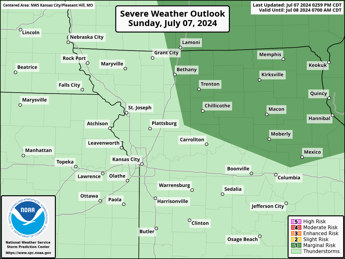
There is also the risk of some stronger storms as well with gusty winds being the issue. We remain in a level 1/5 risk of severe weather with this set-up. Tied really into the evening hours for KC.
For KC’s rain potential we’re going to need the storms to sort of come together as opposed to being isolated things. Keep an eye out for outflows as well to fuel additional development.
IF you miss out on the storms today, and areas farther south of KC may not get much at all, the chances tend to be more scattered tomorrow PM into the weekend. Yes there may well be storms popping but they may not be too organized and that means more isolated right now.
I see some very weak and disorganized waves in the flow, but nothing too strong.
We sort of make a subtle transition to lower dew points early next week…so it may feel a bit more comfortable towards Tuesday so I’m curious if that can be a trigger for additional storms to form in that transition period.
OK that’s it for today. The feature photo is from Christi Bolling of a nice rain shaft from a couple of weeks ago.

Joe
(Except for the headline, this story has not been edited by PostX News and is published from a syndicated feed.)